
Analysis of fire–vulnerable areas in Dongdaemun–gu: Service area analysis for selecting fire–vulnerable areas in Dongdaemun–gu
Published in Proceedings of the Korean Geographical Society Conference, 2022
Abstract: As of 2020, South Korea’s urbanization rate has exceeded 91%. With increasing building density and complex land use resulting from urbanization, fire damage in urban centers is predicted to intensify. In 2020, Dongdaemun-gu recorded 152 fire incidents and suffered property damage totaling 3,392,558,000 KRW, making it the area with the highest fire damage in Seoul. However, the Fire Safety Ratings provided by the Ministry of the Interior and Safety are limited to quantitative figures, making it difficult to evaluate vulnerability from a spatial perspective. Therefore, this study was conducted to identify fire-vulnerable areas based on spatial accessibility characteristics. To analyze fire vulnerability, this research assessed the accessibility of firefighting and medical facilities while identifying the spatial distribution of illegal parking, which hinders such accessibility. Service area analysis was performed to evaluate the accessibility of fire stations and emergency medical facilities, setting arrival time zones at 1, 3, and 5 minutes to account for fire suppression and life-saving efficiency. Furthermore, due to the lack of direct spatial data on illegal parking, the locations of on-street parking lots and illegal parking enforcement CCTVs were used as proxies. On-street parking lots, often installed in areas where off-street or auxiliary parking is scarce, contribute to traffic congestion in narrow alleys or dense commercial districts. Illegal parking CCTVs are typically installed in high-frequency violation areas, making both indicators suitable substitutes for accessibility barriers. The analysis revealed that fire facility service areas showed high accessibility near major roads where facilities are situated, while accessibility was low in topographically challenging areas like mountains or distant regions. Emergency medical facilities showed generally high accessibility near their locations; however, since these facilities are concentrated in the northwestern part of Dongdaemun-gu, accessibility was significantly lower in the southeastern regions. Regarding accessibility barriers, on-street parking was primarily concentrated in Jegi-dong, while illegal parking CCTVs were mainly distributed in the eastern and southern parts of the district. Additionally, fire frequency by administrative ward (Dong) from 2011 to 2020 was identified, with Jangan-dong, Imun-dong, and Jegi-dong showing the highest incident rates. By integrating these data, the study graded fire safety on a scale of 1 to 5, where Grade 5 represents the lowest level of safety. The results showed that Jangan-dong had the highest risk value (lowest safety), while Yongdu-dong had the lowest. This result for Jangan-dong can be attributed to the presence of Baebongsan Mountain between fire facilities, the lack of emergency medical facilities, and the prevalence of narrow roads prone to illegal parking. Consequently, it is concluded that Jangan-dong requires additional firefighting and emergency medical facilities, as well as the enhancement of its road network.
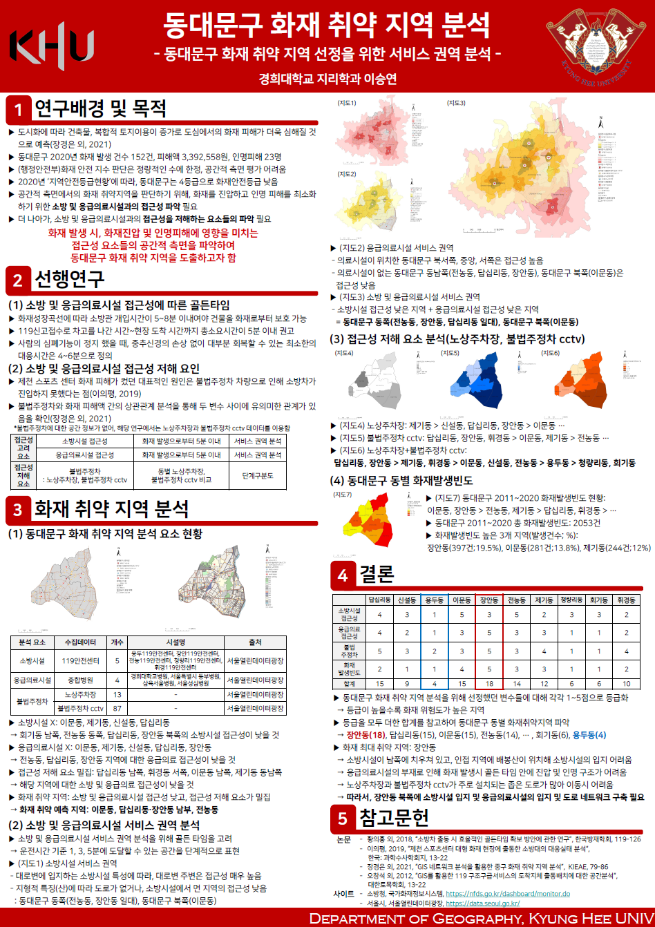 Figure 1. Poster presentation |
Recommended citation: Lee, S. (2022, June). 동대문구 화재취약 지역분석: 동대문구 화재취약 지역선정을 위한 서비스 권역 분석 (Analysis of fire–vulnerable areas in Dongdaemun–gu: Service area analysis for selecting fire–vulnerable areas in Dongdaemun–gu) [Poster presentation]. Proceedings of the Korean Geographical Society Conference Republic of Korea, 263.